The Maneadero Aquifer
by El Berryman
Beneath the eastern base of the Punta Banda Peninsula, including Cantu, the Punta Banda estuary, surrounding agricultural lands, and the “spit” (Lengueta Arenosa), lies the Maneadero aquifer—an underground water source that serves the entire Punta Banda area. Once a naturally balanced system, decades of heavy pumping for farming and growing neighborhoods have pushed this crucial water supply to its limit.
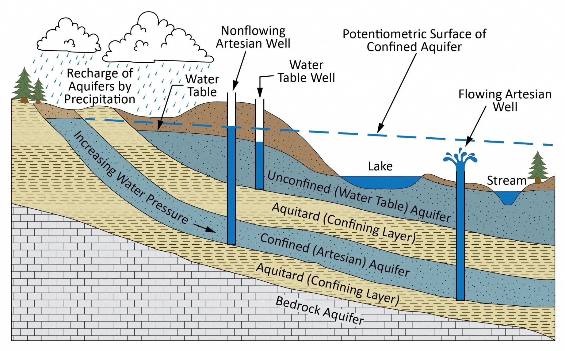
Figure 1. Confined and Unconfined Aquifers. As shown, an unconfined aquifer is deep and sandwiched between two confining layers such as clay or shale. A confined aquifer, such as the Maneadero Aquifer, is shallow with a water table directly connected to open bodies of water. (Source: Marion County Wellfield Education Corporation)
This article explores the fundamentals of groundwater systems, zeroes in on the unique dynamics of the Maneadero Aquifer, and examines the compounding threats and innovative solutions available to sustain the aquifer into the future. In our next issue, we’ll explore where the aquifer’s precious water flows, how it’s treated and distributed, and sustainable solutions for conserving water in the Punta Banda area.
What is an Aquifer?
An aquifer is an underground layer of material such as sand, gravel, or cracked rock that holds and moves groundwater.
Recharge of groundwater into an aquifer can occur via direct infiltration of rainwater, runoff from higher elevations percolating into valley sediments, and irrigation return flow where excess agricultural water infiltrates downward. Once in the aquifer, groundwater moves along hydraulic gradients—generally from higher elevations toward lower elevations, often ultimately discharging into rivers, wetlands, or the ocean.
There are two types of aquifers (Marion County Wellfield Corporation 2022):
Unconfined Aquifers: Located close to the surface. The top of the water level is called the water table, and it rises or falls freely with the weather. Rainwater soaks straight down through the soil to refill the water supply. These aquifers dry out fast during dry seasons because they’re so close to the surface. It’s also easier to drill wells in an unconfined aquifer due to its location near the surface (Figure 1).
Confined Aquifer: Located lie deep below the Earth's surface. These aquifers are sandwiched between tight, heavy layers of impermeable material like clay or shale that block water from moving up or down. Recharge into a confined aquifer is slower than for an unconfined aquifer. It’s also more difficult to drill a well into a confined aquifer, but when you do, the pressure pushes the water high up into the pipe—sometimes even shooting straight out above the ground like a fountain (Figure 1).
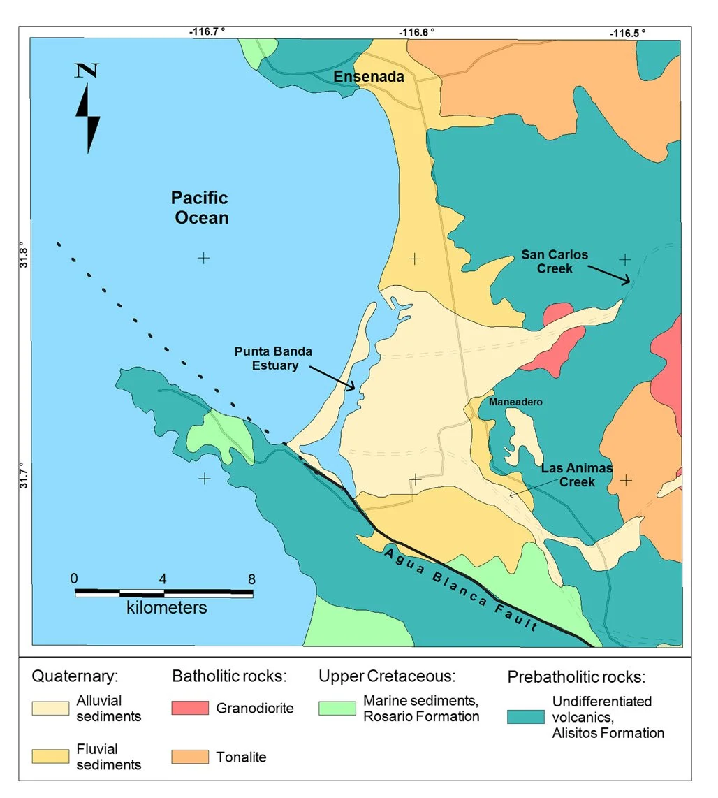
Figure 2. Geologic Map. The Maneadero Aquifer is bounded 10(on the west by the Punta Banda Estuary and the Pacific Ocean, on the south by the Agua Blanca fault and sedimentary rocks, on the north by a river terrace alongside volcanic (Alisitos Formation) rocks, and on the east by volcanic rocks and higher elevation terrain (Daessel et al. 2014)
Where is the Maneadero Aquifer?
The Maneadero an unconfined aquifer is located beneath the Maneadero Valley just south of Ensenada. It’s bounded on the west by the Punta Banda Estuary and the Pacific Ocean, on the south by the Agua Blanca fault and sedimentary rocks, on the north by a river terrace alongside volcanic rocks, and on the east by volcanic rocks and higher elevation terrain (Figure 2: Daessel et al. 2014). The aquifer covers a watershed basin area of roughly 130 km² to 1,975 km² depending physical watershed boundaries used (Villada-Canela et al. 2025).
How is the Maneadero Aquifer Recharged?
While unconfined aquifers normally rely heavily on rainwater, rain is scarce in the arid Maneadero area. Hence, the Maneadero aquifer relies heavily on water running down from nearby hills (namely, intermittent stream flows from the San Carlos and Las Ánimas creeks). Water soaking into the ground from farm irrigation is also a significant source of recharge for the aquifer.
This unconfined aquifer is attached directly to the Pacific Ocean, therefore seawater is another source of aquifer recharge. This is particularly the case when the aquifer has been excessively pumped and and the water table is low.
How did the Maneadero Aquifer Function before Pumping Began?
Before humans started pumping the Maneadero aquifer, it behaved like a balanced coastal groundwater system. Recharge equaled natural discharge to the ocean, groundwater levels stayed high, and saltwater intrusion was minimal (De. In other words, it was a stable, self‑regulating freshwater basin and discharge was gentle and predicable. Groundwater flowed down‑valley toward the coast, and freshwater was discharged into the Punta Banda estuary and the ocean. Because recharge and discharge were roughly equal, the aquifer maintained a stable water table. (Daessle 2004)
The Importance of the Maneadero Aquifer for Local Ecosystems
Estuary and Dunes
The Maneadero Aquifer sustains the nearby Punta Banda Estuary by delivering steady subterranean freshwater flows that regulate salinity and maintain the delicate brackish (part salty, part fresh water) conditions of the coastal ecosystem. When the aquifer functions as a balanced system, it prevents over-salinity, preserving the specialized salt marsh vegetation—such as pickleweed and cordgrass—that stabilizes shorelines and buffers against erosion. The balanced wetlands and associated dune habitats serve as vital nesting grounds for sensitive coastal birds like the California Least Tern and Light-footed Ridgway's Rail. (Guimond and Tamborski 2021)
Shallow Marine Habitats
Freshwater discharging from the Maneadero aquifer also plays a vital role in sustaining marine life in the estuary and open nearshore waters. When the aquifer functions as a balanced system constant flow moderates coastal salinity, preventing ocean waters from becoming excessively salty during hot, dry spells while delivering essential terrestrial nutrients that nourish marine food webs. These stable conditions allow eelgrass meadows to flourish, creating rich "underwater forests" that serve as critical shelter, feeding grounds, and nurseries for juvenile fish, crabs, and foraging seabirds. Beyond supporting biodiversity, healthy eelgrass beds pump oxygen into the water column, trap suspended sediments to maintain water clarity, and buffer coastal shorelines against erosive wave action. Protecting subterranean freshwater flows ensures these coastal habitats remain resilient, safeguarding marine species from the shoreline out into the open ocean. (Lecher et al. 2019)
Upland Habitats
The shallow, unconfined Maneadero Aquifer is essential to Punta Banda’s upland ecosystems because its surface-connected water table directly hydrates the root zones of surrounding plant communities. By allowing direct groundwater infiltration and lateral moisture movement through the soil, it provides a crucial hydrological buffer during long dry seasons, enabling deep-rooted chaparral and coastal sage scrub to survive drought, prevent soil erosion, and reduce wildfire risks on the hillsides (Ackerly 2004). Additionally, this elevated water table feeds riparian corridors with the subterranean freshwater required to sustain cottonwoods, willows, and vital wildlife passage (Lite and Stromberg 2005). Preserving this groundwater supply maintains the biological resilience of the entire upper watershed.
Humans as a Component of the Ecosystem
Humans are also a core component of an ecosystem because they actively participate in its natural cycles—consuming resources, reshaping physical landscapes, and altering food webs—while remaining entirely dependent on its ecological services for survival. Humans have become an indivisible component of the Punta Banda ecosystem, relying directly on its shared watershed for agricultural livelihoods, drinking water, and other household water uses. Unfortunately, population growth and growing demands for water have resulted in over-extraction, throwing off the balance of the Maneadero Aquifer system.
Aquifer Depletion and Other Impacts Related to Human Use
The Maneadero aquifer is one of the primary groundwater sources relied upon for Ensenada’s municipal supply and surrounding areas for urban and agricultural needs. With current rates of Maneadero Aquifer pumping for human uses, there isn’t enough recharge to offset extraction. Research shows that while the allocated volume of extraction reaches approximately 39.06 million cubic meters annually, the natural recharge from meager regional rainfall sits at just 33.7 million cubic meters, triggering a persistent yearly deficit of 5.37 million cubic meters. (Conagua 2020)
Water Scarcity
The aquifer’s deficit leads to sharply diminished water availability across the Maneadero Valley. As the aquifer’s water levels plummet, the regional water table continues to drop, forcing local farmers to dig deeper or run pumps for longer periods to extract increasingly limited fresh reserves. The regional water scarcity is further exacerbated by recurring, multi-month droughts and the impacts of climate change, which significantly restrict the natural surface water and mountain runoff that historically recharged the basin.
Salinization
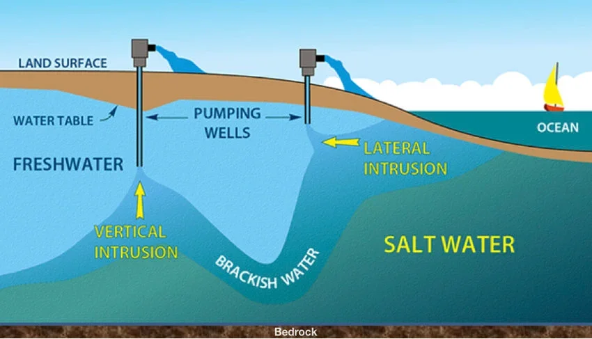
Figure 3. Salinization. With an unconfined aquifer connected to the ocean, sea water intrudes into aquifer as a result of excess pumping. (Buzzanga 2017)
Because the Maneadero basin forms contiguous water masses with the Pacific Ocean, the vacuum created by heavy inland pumping draws marine water inland (Figure 3; Buzzanga 2017). Seawater intrusion has progressed steadily from west to east, penetrating up to 4 kilometers inland from the coast. This influx of marine water has triggered widespread salinization, driving total dissolved solids (TDS) concentrations to levels ranging from 1.1 to 26.9 grams per liter—dramatically overshooting the maximum permissible drinking water limit of 1.0 gram per liter mandated by Mexican regulatory standards. Continued sea level rise as a result of climate change is expected to exacerbate salinization of the aquifer. (Daessle et al. 2014)
Altered Water Gradients Pulling Pollution into the Aquifer
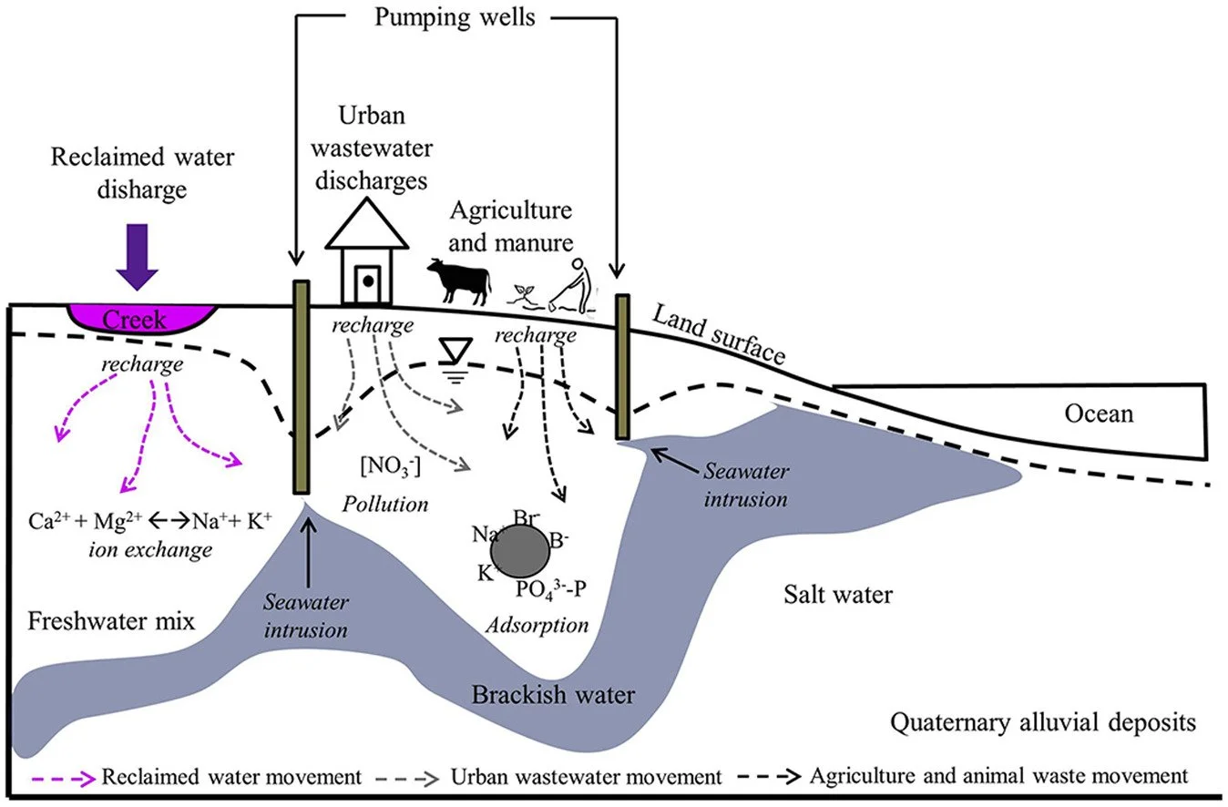
Figure 4. Saltwater Intrusion/Pollution. When the freshwater aquifer is over-pumped, not only does this increase seawater intrusion but it also draws in polluted household and agricultural wastewater. Treated, reclaimed wastewater is viable solution to aquifer depletion. (Gilabert-Alarcón et al. 2018)
In addition to salinization, aggressive groundwater pumping has altered the underground water gradients, drawing water pollution deeper into the water supply (Figure 4. Gilabert-Alarcón et al. 2018). Elevated concentrations of nitrates have been detected in various wells, acting as a clear indicator of chemical fertilizer infiltration and agricultural runoff. Additionally, because less than 13% of the valley's population is connected to a formal public sewage system (Elizondo and Mendoza-Espinosa 2020), the lack of infrastructure means that untreated domestic waste, wastewater, and animal waste easily migrate downward , compounding chemical pollution with microbial and organic contaminants. (Cui et al. 2026)
Sustainable Solutions
Sustainable solutions for the Maneadero aquifer in Baja California, Mexico, focus on wastewater reuse and reclamation, .
Wastewater Reuse and Reclamation
Wastewater reuse and reclamation offer a vital pathway toward sustainable groundwater management by significantly reducing the pressure on over-extracted aquifers. Utilizing treated effluent from facilities like the El Naranjo wastewater treatment plant for crop irrigation drastically lowers the demand for fresh subterranean water in the agricultural sector (Figure 4, Gilabert-Alarcon et al. 2018). Additionally, implementing Managed Aquifer Recharge (MAR) by discharging high-quality reclaimed water into local creeks and infiltration basins artificially replenishes depleted aquifers while establishing an essential hydraulic barrier to prevent seawater intrusion into coastal freshwater supplies ((Elizondo and Mendoza-Espinosa 2020, Cruz-Ayala and Megdal 2020, Gilabert-Alarcon et al. 2018).
Collaborative Water Planning
Collaborative water planning (also known as integrated water governance) fuses grassroots stakeholder collaboration with rigorous scientific oversight to establish equitable, sustainable aquifer management. By involving local farmers, community organizations, and regional stakeholders directly in decision-making frameworks, water authorities cultivate public trust, improve policy compliance, and ensure fair resource distribution across agricultural and municipal sectors (Villada-Canela 2021). Concurrently, maintaining continuous, data-driven monitoring of groundwater hydrology and water quality provides the empirical backbone necessary for safe management. This scientific vigilance ensures that managed recharge initiatives and reclaimed water programs do not introduce harmful contaminants or public health risks, safeguarding the aquifer's ecolo gical and structural integrity for future generations (Villada-Canela 2021, Gilabert-Alarcon et al. 2018).
Although integrated water governance is recognized as an essential strategy for managing the Maneadero Aquifer's chronic overdraft, its practical application remains fragmented under centralized, top-down state control (Villada-Canela 2021). Official entities like CESPE incorporate sustainable resource concepts into administrative planning, yet collaborative management also requires grassroots efforts—where local agricultural producers, academic researchers, and civic advocacy groups mobilize for reclaimed wastewater utilization from the local treatment plant, systematic groundwater salinity monitoring, and managed aquifer recharge initiatives (North American Development Bank, accessed 9/14/2026). Transitioning from this piecemeal approach to a fully realized governance framework requires bridging bureaucratic divides, resolving chronic infrastructure deficits, and institutionalizing transparent, data-driven decision-making across all local stakeholders dependent on this vital coastal aquifer.
This institutional friction is further compounded by major legal and financial hurdles that limit the power of local community efforts within the Maneadero Valley. In Mexico, water rights, basin allocations, and infrastructure funding are tightly controlled by state and federal agencies like CESPE and CONAGUA, leaving local groups without the legal power to make binding decisions regarding aquifer extraction limits or discharge protocols. On top of that, running real aquifer restoration takes high-tech equipment, constant hydrological testing, and millions of dollars—resources that local farming groups (ejidos) and environmental volunteers simply do not have on their own. Differing priorities between big commercial farms needing irrigation and city residents needing reliable drinking water also make it tough to stay united. As a result, even though local researchers, residents, and civic groups like Todos Somos Maneadero actively push back against utility failure—sometimes even prompting government environmental enforcement—their grassroots work remains mostly advisory and reactionary, rather than having a formal seat at the governing table for the Maneadero Aquifer. (Medellín-Azuara et al. 2013)
Aquifer Management and Alternative Supply Diversification
Sustainable aquifer management requires a proactive approach to demand management and supply diversification to mitigate overdraft and ensure long-term regional water security. Supporting local agricultural operations in adopting high-efficiency micro-irrigation systems, alongside transitioning to climate-adaptive crop species, directly curtails overall groundwater extraction volumes without compromising yield (Guillen 2022). Furthermore, relieving stress on vulnerable coastal basins depends on balancing groundwater extraction with a diversified portfolio of alternative regional water sources, provided planners carefully evaluate the environmental footprint and energy costs associated with desalination and long-distance aqueduct imports (Elizondo and Mendoza-Espinosa 2020).
Household Water Conservation
Of course, the most direct way for Punta Banda community members to help sustain the Maneadero Aquifer is to limit their water use. Our next issue will focus on water delivery, treatment, and use in the Punta Banda area, as well as local water conservation opportunities.
-by El Berryman
Unlinked Sources:
CONAGUA (2020). Actualización de la disponibilidad media anual de agua en el acuífero Maneadero (0208), Estado de Baja California. Diario Oficial de la Federación / Comisión Nacional del Agua.